All components in place for potential Central African-style copper mineralization
Highlights
Several large, near-surface conductors representing potentially reductive permeable stratigraphy favourable to host sediment-hosted copper mineralization delineated by airborne MobileMT geophysical survey
New sampling verifies historical occurrences, including Payback Showing (up to 61.2% copper ("Cu") with 5,600 grams per tonne ("g/t") silver ("Ag")) and CBC Showing (up to 9.9% Cu, 1.9% lead ("Pb"), 3.5 g/t gold ("Au") and 431 g/t Ag)
Multiple new copper, zinc and lead occurrences were discovered across the property in 2024 sampling, along with locally anomalous gold, silver and cobalt
Additional mineral claims staked on prospective ground expanding claim block by 11,608 hectares ("ha") to a total of 102,108 ha (1,002 square kilometres ("km2))
TORONTO, ON / ACCESS Newswire / June 5, 2025 / Aston Bay Holdings Ltd. (TSXV:BAY)(OTCQB:ATBHF) ("Aston Bay" or the "Company") is pleased to report on sampling, mapping and geophysical programs at the Epworth Project ("Epworth" or the "Project") in Nunavut.
Thomas Ullrich, Chief Executive Officer of Aston Bay, commented:
"Analysis of the 2024 exploration programs at Epworth is delivering exciting results pointing to the potential for large-scale copper mineralization at the property.
"The surface sampling programs have confirmed previous work where large boulders yielding up to 61.2% copper with 5,600 g/t silver were found at the surface along with several other zones of high-grade metal mineralization. With significant lead, zinc, gold and anomalous cobalt in several newly discovered areas on this large property, we have only scratched the surface.
"These are excellent results, but with mineralization typically confined to structurally controlled fracture filling (veins), building significant tonnage of mineralized material can be challenging. The widespread nature of the metal mineralization, however, points to the potential for large-scale stratigraphically-controlled mineralization at depth - this is the sediment-hosted copper deposit model used to find the large copper deposits of Central Africa and successfully used at our other project, Storm Copper.
"Of the key components required to form an extensive sediment-hosted copper system, the discovery of these conductors provides the final piece of the puzzle at Epworth: these conductors may represent the reductant, in the form of pyrite or graphite in a permeable horizon, that forces the precipitation of metals over large areas within this stratigraphic unit and bounding faults. The first interaction of metal-bearing fluids with a reductant is the site of metal sulfide deposition in this model, providing a large target of potential metal accumulation. As well, the conductors may represent some metal sulfide mineralization themselves.
"These are compelling targets tens of kilometres in scale, mostly within 300m from the surface. We continue to work with the data to refine optimal drill targets for a potential drill program later this season."
MobileMT Survey Summary
In late summer 2024, a property-wide airborne MobileMT (Mobile MagnetoTelluric) geophysical survey was completed at the Epworth Project in Nunavut. The survey, conducted by Expert Geophysical Systems, covered 8,105 line-kilometres across the entire extant claim block, with 100-metre line spacing in the northern half and 200-metre spacing in the southern half to ensure high-resolution data over priority areas.
The MobileMT system utilizes naturally occurring electromagnetic fields generated by global lightning activity. By measuring both magnetic and electric field variations, the system provides high-resolution geoelectrical data from the surface to depths exceeding one kilometre. This allows for the detection of resistivity contrasts associated with geological structures, alteration zones, and potential mineralized bodies in any orientation.
Preliminary Results - Apparent Conductivity
The purpose of the survey was mapping of bedrock structures and lithology, including possible alteration and mineralization zones reflected in the electrical and magnetic properties of rocks. The airborne geophysical survey results are presented as apparent conductivity corresponding to different frequencies, resistivity-depth profiles determined from inverting EM data, available VLF EM data, as well as magnetic field data and its derivatives.
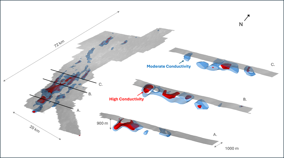
Inversion of the data yielded a 3D voxel representation of apparent conductivity that is dominated by extensive conductive bodies spatially associated with the southern portion of the Proterozoic Recluse Group rocks, a sedimentary succession of sandstones and carbonate rocks (Figures 1 through 3). Formations comprising the group are locally pyritic and graphitic, both potential reductants for metal-bearing fluids, and coarsen to the south, potentially increasing permeability and porosity for metal deposition. Three cross-sections through the more conductive southern portion of the claim block (Figure 1) show the higher conductivity bodies extending from near-surface, dominantly to approximately 300m depth, extending locally to 900m at the western fault contact.
It is postulated that the apparent conductivity reflects the pyrite or graphite in the Recluse Group rocks, and that these rocks may act as a potential trap for metal-bearing fluids. The stronger conductivity to in the southern portion of the claim block may even represent metal sulfide accumulation in the more porous southern Recluse rocks.
Frequency in electromagnetic surveys, such as MobileMT, controls for depth of investigation, with lower frequencies penetrating deeper into the ground, making the apparent conductivity measurement more representative for deeper layers. Higher frequencies are more sensitive to shallow subsurface features, as their electromagnetic fields attenuate more rapidly with depth.
Deeper apparent conductivity anomalies may represent the stratigraphic targets at Epworth, while shallow apparent conductors may represent the structural/fault-controlled mineralization at the surface. Figure 2A shows an excellent spatial coincidence of the deeper, low-frequency conductor (42 Hz, blue and white colours) with the Recluse Group. Surface mineralization at the historic at-surface Metallic (northern showings) and CBC (southeastern showings) shows a correlation with shallower, high-frequency conductors (453 -8550 Hz, green to red colours). In addition, examination of the derivatives (i.e., abruptness of change in the conductivity, Figure 2B) show a good correlation to known surficial mineralization, likely associated with mineralization along vertical structures and faults. Future exploration will examine the potential of other, near-surface conductors.
Although the stratigraphic target represented by the deeper apparent conductor presents the more immediate compelling target, mineralization taking advantage of structural corridors also remains a valid target for further exploration.
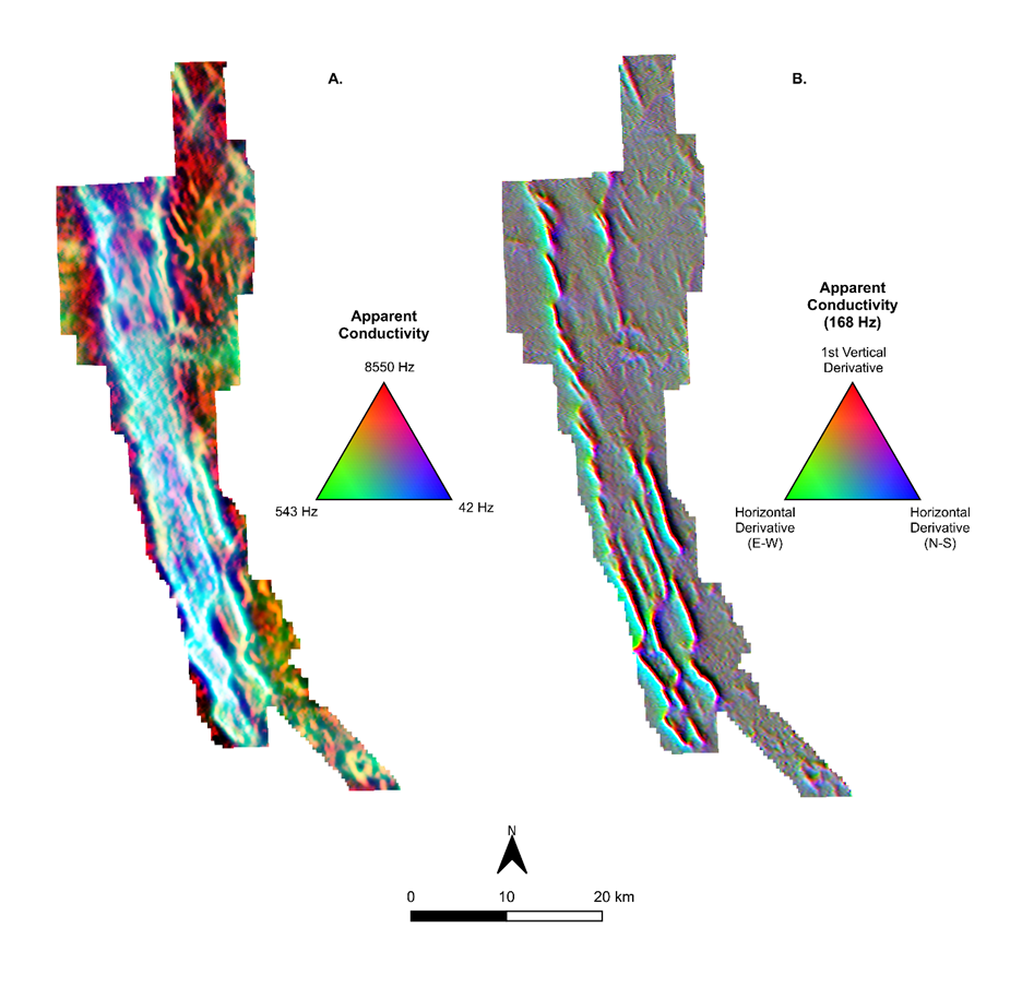
A. Grid composite image for three frequencies of apparent conductivity that highlights conductors that are close to or at surface in red and brown, and those that extend from near surface to depth in white and blue. The deeper (while/blue) conductors appear confined to the sedimentary rocks of the Recluse Group.
B. Grid composite image of 168 Hz and its vertical and horizontal derivatives to highlight conductors, whether strong or weak, detected at this frequency, highlighting shallow conductors.
A program is underway to integrate all results with new geological mapping, rock and lake sediment sampling, and historical geophysical data to generate and prioritize targets for follow-up exploration and potential drilling in 2025. This work is ongoing, with additional analyses and reports expected over the coming weeks.
Permits are in hand for the first phase of modern drilling in the northern claim area; work is underway to modify the permitted locations for the new targets in the southern claim block.
New Staking and 2024 Field Program
The 2024 Epworth exploration program took place from July 15th to August 18th, based out of four fly-camps on four separate lakes, targeting numerous prospective areas on the property. An inflatable boat was used to facilitate travel from campsites and collect lake sediment samples. Nine additional claims, adding an additional 11,900 ha of ground, were staked during the program, and, after the field program and motivated by the Mobile MT geophysical program results, an additional 11,608 hectares were staked in June 2025 (Figure 3).

A total of 362 rock grab samples and 34 lake sediment samples were collected on the current claims during the program. A summary of significant results is presented below (Figure 3). Rock grab sample results maps are presented by element (Cu, Zn, Pb, Co, Ag, Au) and Lake sediment sample results maps, separated by precious metals and base metals, are available on the Aston Bay website.
Payback - Metallic South Area
The Payback trend, towards the northern end of the current property, was historically targeted by Noranda Exploration in the 1990s.
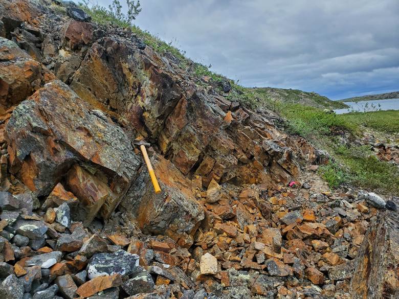
At the historical Payback South showing, boulders which previously returned up to 61.2% Cu with 5,600 g/t Ag were located and re-sampled during the 2024 program, returning up to 52.9% Cu, up to 3,880 g/t Ag, and up to 233 ppb Au. The boulders, along with numerous similar rock chips, are located in a series of frost boils on the flank of a diabase dyke. They are composed largely of massive bornite or chalcocite with quartz.
Payback South boulders, looking east.
At the historical Payback North showing, located approximately 3 km north-northwest of Payback South, mineralized zones were located and sampled during the 2024 program, and historical drill pad sites were located. Noranda drilled two very shallow holes there, totalling 99.5 meters, with one of the holes returning 0.3% Cu over 8.3 meters, from dolomite with microfracture-hosted chalcocite. 2024 rock grab samples along the drilled horizon returned up to 17.9% Cu, with 14 grab samples returning >1% Cu along a strike length of 225 meters, open to the north and south.
Approximately 1.5 km across strike to the east of the Payback Trend, a 1.3 km Zn-Pb trend was identified in 2023, subparallel to the Payback Trend, with Zn results up to 16.2% and Pb results up to 2.8%, as sphalerite-galena stringers or blebs in a dolomite horizon in outcrop. The anomalous trend was extended to the south in 2024, for a total length of 2.2 km. New samples along the southern extension returned up to 4.8% Zn and 3.0% Pb. This area may represent the southern strike extension of the horizon(s) hosting the Metallic Trend, 9 km to the north-northwest. The Metallic Trend is a 1.1 km trend of high-grade mineralization which yielded grab sample results up to 37.8% Cu, 27.4% Zn, 19% Pb, 3 g/t Au, 1,130 g/t Ag, and 1700 ppm Co from 2021-2022. From over 300 total historic rock grab samples, 51 samples yielded over 1% Cu, 29 samples yielded over 30 g/t Ag, and 15 samples yielded over 1% Zn.
Rusty Valley Area (NW Claims)
The Rusty Valley area is located in the northwestern part of the Epworth property. The 2024 field program targeted base metal anomalies in historical lake sediment samples and copper values up to 2.5% in historical grab samples, collected by Noranda.
A prominent gossan zone on the western flank of a >100-meter-wide valley was identified during the 2024 program. Mineralization consists mainly of pyrite within black shale, but zinc anomalies up to 1.13% Zn were also obtained. An angular boulder of a strongly silica-altered rock also returned a gold value of 535 parts per billion ("ppb") Au. The mineralized zone, open to the east within the valley, is associated with a prominent conductive trend that runs down the property's west side for 62 km.
Gossan zone at Rusty Valley, looking north
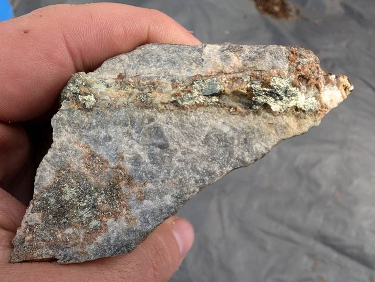
Approximately 300 meters west of the gossan zone, a horizon of dolomite was located hosting chalcopyrite stringers sporadically across a width of at least 20 meters (named the ‘Slope Showing'). Grab samples of this mineralization in outcrop or frost heave returned up to 4.03% Cu. A composite sample of frost-heaved, malachite-stained rock chips on the west side of the dolomite outcrop, close to the contact with grey shale to the west, returned 37.0% Cu.
Chalcopyrite-rich vein in dolomite at Slope Showing
The dolomite unit was traced at least 2 km further to the north, where samples of frost heave returned up to 9.15% Zn, up to 11.7% Pb, and up to 150 ppb Au.
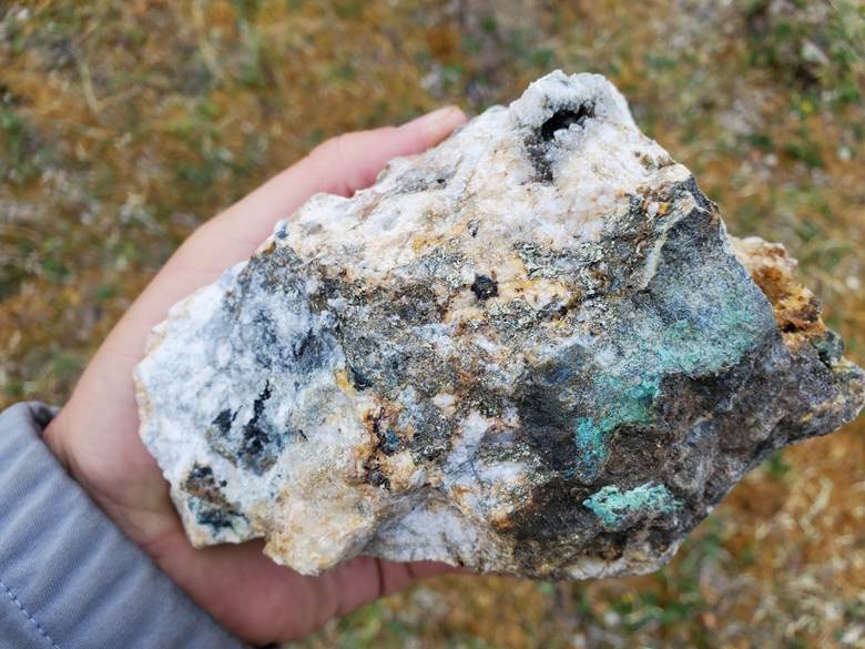
A further 300 meters across strike to the west of the dolomite unit, base metal mineralization was located in angular boulders of brecciated clastic metasediments with quartz veining and gabbro outcrop with calcite stringers. These returned up to 3.4% Cu, up to 2.3% Zn, up to 0.8% Pb, and up to 337 ppb Au.
Quartz vein with chalcopyrite, malachite staining from brecciated clastic metasediments
850 meters south-southwest of the previous area, subcrop of shale with chalcopyrite-bearing quartz veining was sampled, returning up to 2.0% Cu.
All of the above mineralization is believed to be newly discovered. However, two clusters of historical Noranda samples are located approximately 800 meters and 3.1 km south-southeast of the last-mentioned area, with past results of up to 2.5% and 2.4% Cu, respectively. 2024 sampling in these areas returned up to 2.1% Cu in the first area, and 0.9% Cu with 157 ppb Au in the second area.
Anomalous mineralization in the Rusty Valley area has been identified along a strike length of approximately 5.7 km. The findings from the 2024 program indicate a much broader mineralizing system than previously recognized in this area, with multiple subparallel mineralized zones in shale, dolomite and mafic dykes.
JM Area (SW Claims)
Prospecting and sampling was carried out in the southwestern portion of the property close to the western property boundary and near Noranda's historical JM showing, which returned past results up to 6.8% Zn and 0.25% Pb, from dolomite with disseminated sphalerite and galena. This style of mineralization was not located during the 2024 program; however, gossanous quartz veins up to 0.8 m thick in the area returned up to 2.9% Zn.
A new copper showing was identified 2.7 km west of the JM showing, returning up to 1.1% Cu (with 92 ppb Au) from dolomite with chalcopyrite and chalcocite stringers in outcrop. The showing occurs on the east side of a stream valley which flows into a lake to the north, where one of the four program campsites was located. This lake yielded the program's best Cu and Zn Lake sediment sample anomalies, 133 ppm Cu and 300 ppm Zn.
CBC Area
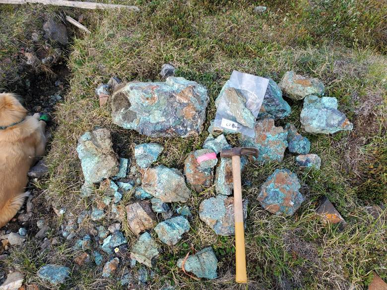
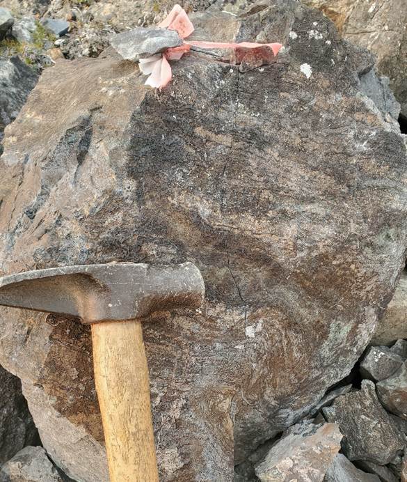
Prospecting and sampling were carried out in the southeastern limb of the property near the historical CBC Showing, where a cluster of angular boulders in a valley returned past results of up to 9.9% Cu, 1.9% Pb, 3.5 g/t Au and 431 g/t Ag, hosted in organic-rich dolomite. The boulders were located in the 2024 program and re-sampled, with results of up to 3.6% Cu, up to 485 ppb Au, up to 2.3% Pb, and up to 205 ppm Ag.
Historical flagged sample of organic-rich dolomite boulder at CBC Showing
160 m south-southeast of the main cluster of boulders, a mineralized outcrop on the west side of the target valley returned 0.54% Cu, 11.3% Zn, 11.5% Pb, 157 ppb Au, 128 ppm Ag, and 161 ppm Co, hosted in fractured dolomite with >5% disseminated sulphides.
3 km further to the south-southeast, a cluster of angular boulders with base metal mineralization was located on an island in the lake south of the showing. These boulders returned up to 2.0% Cu, up to 317 ppb Au, up to 358 ppm Ag, up to 4.2% Zn, and up to 7.4% Pb. Mineralization is hosted mainly within white quartz veinlets in dolomite.
750 meters north of the lake, dolomite with several thin (<5cm) layers of grainstone, mineralized with disseminated pyrite and chalcopyrite, was sampled in outcrop. Samples returned up to 0.3% Cu and up to 1060 ppm Co.
On the west side of the lake, a sub-rounded 1.5m long boulder of amphibolite with 5-10% pyrrhotite +/- chalcopyrite was sampled, returning 6.0 g/t Au. This is the highest known gold value on the property to date, though the source of the boulder is unknown.
Geological, Structural, and Petrological Studies
Dr. Elizabeth Turner completed a preliminary mapping and rock sampling program in conjunction with the 2024 field program and the early phase of the geophysical survey, based out of Kugluktuk, NU by helicopter. She is currently in the process of analyzing the geological, structural, and petrological data. Her observations, in conjunction with field program results and geophysical data, will assist greatly in understanding the controls on mineralization in areas of interest.
Community Engagement
Aston Bay looks forward to joining Emerald Geological Services in continuing meetings with the local Hunters and Trappers Association and community members this season in Kugluktuk.
Qualified Person
Michael Dufresne, M.Sc., P.Geol., P.Geo., and Coleman Robertson, B.Sc., P.Geo., are qualified persons as defined by National Instrument 43-101 and have reviewed and approved the scientific and technical information in this press release.
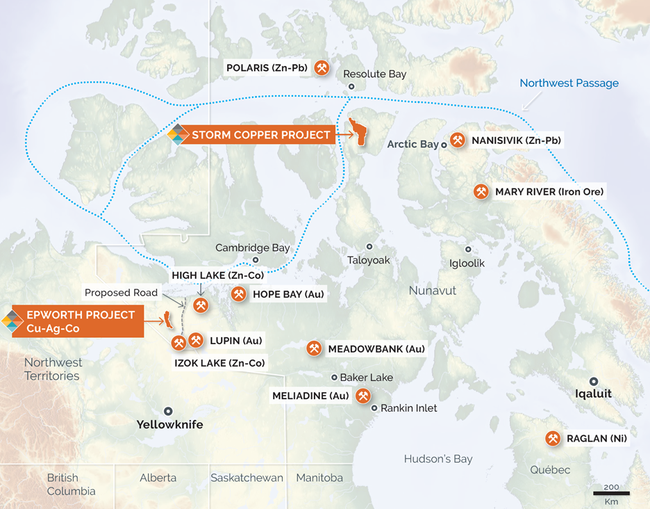
About the Epworth Property
The Epworth Property is located approximately 80 km southeast of the village of Kugluktuk (formerly Coppermine) in the Kitikmeot Region of Nunavut, Canada. The property is approximately 70 km from tidewater to the north. Logistical access is provided by float plane and helicopter from Kugluktuk and the city of Yellowknife, 500 km to the south. The property now consists of 73 claims covering an area of approximately 102,108 ha (1,002 km2) over a trend approximately 82 km in strike length and 20 km in lateral extent.
Location of the Epworth Property, Nunavut, Canada.
Agreement
Aston Bay has entered into an agreement with Emerald Geological Services whereby Aston Bay can earn an 80% undivided interest in the Property by spending a minimum of $3 million on qualifying exploration expenditures over a four-year period. See Aston Bay April 24, 2024, news release.
Geology
The Epworth Project is part of a broad platform-type clastic carbonate sequence belonging to the early Proterozoic Coronation Supergroup that extends from the north shore of Takijuq Lake to the Coronation Gulf for over 130 km. Polymetallic sulfide mineralization occurs as disseminations in the matrix of coarse clastic quartzites or as concordant zones of cherty replacements within permeable dolomite. The mineralization assemblage, stratigraphy, diagenetic evolution, and rift-related tectonic setting of the Coronation Supergroup compares favourably to the African Copperbelt that hosts large (>100mt) high-grade (3-4% Cu) sediment-hosted stratiform copper deposits.
History and recent work
The Epworth Project was explored by Noranda Mining and Exploration in the mid-1990s, resulting in the discovery of new base metal showings. Chalcocite boulders at surface yield up to 61.2% Cu with 5600 g/t Ag in select rock grab samples. Prospecting, mapping, geophysics and sparse drilling (only 132m in the original claim block, <2000m total historic drilling over the expanded claims) were conducted over four exploration seasons. The best intercepts yielded 10.4% Cu over 0.9m, 0.3% Cu over 8m, and 18.4% Cu with 302 g/t Ag over 0.3m in very shallow drilling in 1995-6. The Epworth Project has not been drilled since, and no modern geophysical surveys have been conducted.
Prospecting programs in the 2020s have defined several trends in conjunction with historical work. Recent rock grab samples up to 38% Cu, 1100 g/t Ag, 3.0 g/t Au, 27% Zn, 17% Pb along with 1700 ppm Co and other anomalous mineralization define the 2.8 km long "Metallic Trend." From over 300 total historic rock grab samples, 51 samples yielded over 1% Cu, 29 samples yielded over 30 g/t Ag and 15 samples yielded over 1% Zn. Prospecting and soil sampling have yielded promising new trends and showings such as the new Northeast Showing discovered in 2023 yielding up to 19% Pb and 0.8% Cu in rock grab samples.
QA/QC Protocols
Grab samples at the Epworth Property were collected, documented and photographed in the field by Emerald Geological Services (EGS) personnel, then placed in sealed bags and periodically sent out by float plane from the camp to a secure location in Yellowknife. Subsequently the sample bags, sealed with security tags, were shipped by transport to Activation Laboratories (ActLabs) in Thunder Bay, which is an ISO / IEC 17025 accredited laboratory. Grab sample collection is subject to EGS's internal quality assurance / quality control (QAQC) protocols, which include the insertion of blank material and certified reference material into each batch of samples submitted. Rock samples referenced in this news release were analyzed using ActLabs method "UT-6M," a 4-acid total digestion with ICP-OES/MS finish, yielding geochemical results for 48 elements. Samples with over-limit base metal results were further analyzed by ActLabs method "8-Peroxide ICP-OES", a sodium peroxide fusion with ICP-OES finish. Samples with over-limit silver results were further analyzed by ActLabs method "8-4 Acid Total Digestion", a total digestion with ICP-OES finish. All samples were also analyzed using ActLabs methods "1A2-50," a 50g fire assay with atomic absorption finish for gold, with over-limit results analyzed using method "1A3-50," a 50g fire assay with gravimetric finish. Lake sediment samples referenced in this news release were analyzed using ActLabs method "1F2," a total digestion with ICP-OES finish, yielding geochemical results for 35 elements. They were also analyzed using ActLabs method "5b" for gold using Instrumental Neutron Activation Analysis (INAA).
About Aston Bay Holdings
Aston Bay is a publicly traded mineral exploration company exploring for high-grade critical and precious metal deposits in North America.
The Company is currently exploring the Storm Copper Property and Cu-Ag-Zn-Co Epworth Property in Nunavut. The Company is also in advanced stages of negotiation on other lands with high-grade precious and critical metals potential in North America
The Company and its joint venture partners, American West Metals Limited and its wholly-owned subsidiary, Tornado Metals Ltd. (collectively, "American West"), have formed a 20/80 unincorporated joint venture in respect of the Storm Project property, which hosts the Storm Copper Project and the Seal Zinc Deposit. Under the unincorporated joint venture, Aston Bay shall have a free carried interest until American West has made a decision to mine upon completion of a bankable feasibility study, meaning American West will be solely responsible for funding the joint venture until such decision is made. After such decision is made, Aston Bay will be diluted in the event it does not elect to contribute its proportionate share and its interest in the Storm Project property will be converted into a 2% net smelter returns royalty if its interest is diluted to below 10%.
FORWARD-LOOKING STATEMENTS
Statements made in this news release, including those regarding entering into the joint venture and each party's interest in the Project pursuant to the agreement in respect of the joint venture, management objectives, forecasts, estimates, expectations, or predictions of the future may constitute "forward-looking statement", which can be identified by the use of conditional or future tenses or by the use of such verbs as "believe", "expect", "may", "will", "should", "estimate", "anticipate", "project", "plan", and words of similar import, including variations thereof and negative forms. This press release contains forward-looking statements that reflect, as of the date of this press release, Aston Bay's expectations, estimates and projections about its operations, the mining industry and the economic environment in which it operates. Statements in this press release that are not supported by historical fact are forward-looking statements, meaning they involve risk, uncertainty and other factors that could cause actual results to differ materially from those expressed or implied by such forward-looking statements. Although Aston Bay believes that the assumptions inherent in the forward-looking statements are reasonable, undue reliance should not be placed on these statements, which apply only at the time of writing of this press release. Aston Bay disclaims any intention or obligation to update or revise any forward-looking statement, whether as a result of new information, future events or otherwise, except to the extent required by securities legislation.
Neither TSX Venture Exchange nor its regulation services provider (as that term is defined in policies of the TSX Venture Exchange) accepts responsibility for the adequacy or accuracy of this news release.
For more information contact:
Thomas Ullrich, Chief Executive Officer
thomas.ullrich@astonbayholdings.com
(416) 456-3516
Sofia Harquail, IR and Corporate Development
sofia.harquail@astonbayholdings.com
(647) 821-1337
SOURCE: Aston Bay Holdings Ltd.
View the original press release on ACCESS Newswire